Greetings!
It’s Easter Time, the holiest of the year and so I’ve spent much of the last week in church. Which got me to thinking about my top five religious destinations to check out:
5). Demir Baba, Sveshtari, Bulgaria – gorgeous Sufi shrine in north-eastern Bulgaria. Powerful Balkan spirituality.
4). Pushkar, India – Pushkar pool at sunset with the temple bell ringing and birds flying overhead…
3). Golden Temple, Amritsar, India – this place is incredible; such energy and aura. Eat langar and pray in the Hari Mandir in Amritsar, you’ll never forget it!
2). Glastonbury, UK – England’s holy heart. Both Christian and Pagan with a unique and powerful vibe.
1). Jerusalem, Israel – it couldn’t really be anywhere else now, could it? Three faiths and a plethora of intriguing sites. Spiritually powerful but also sobering for the modern-day implications.
Keep travelling!
Uncle Travelling Matt
Links to all parts of this travelogue
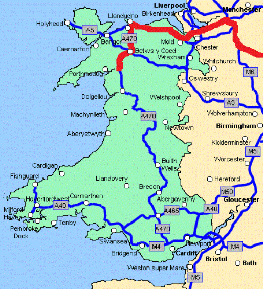
Part 3: Llandudno to Dolwyddelan
Part 4: Dolwyddelan to Blaenau Ffestiniog
Also check out my other Welsh travelogues:
V-log: Walking Pilgrimage to Bardsey Island
Part 4: Dolwyddelan to Blaenau Ffestiniog
Whenever I bring a foreigner to Wales, I bring them to Dolwyddelan. I've shown it to Americans, Vietnamese, Irishmen and a Dutchman so far but they won't be the last. I bring them to Dolwyddelan partially because it is beautiful, powerfully so, but then there are plenty of places that fit that description in Cymru. No, the main reason why Dolwyddelan is on my itinerary is because Dolwyddelan is Wales; for me it represents the country's very soul. Which of course begs the question as to why try and find the soul of Wales by travelling the A470 when one already knows where it is? Well, who knows? Perhaps I've got it wrong.
And I may well have. Disappointingly, Cerys Matthews never once talks about it on her tour of the Welsh M1 and it doesn't even get a mention in Lorraine King's musical tribute to the road. Yet it should for it is undoubtedly the most spectacular ruin en route, or at least, that's my opinion.
Dolwyddelan – a combination of “Dol” (field) and “Gwyddelan” (Irishman) – is the field of the Irishman. It was founded back in the murky mists of the Dark Ages when an unknown Irish holy man headed up the Lledr Valley and decided to erect his hermitage where the village now stands. St. Gwyddelan is my favourite Welsh saint for we known absolutely nothing about him, not even his name, yet his legacy persists, not only in the settlement that he founded but also in the church which superseded the one that he founded for there we can find his bell hanging up in the nave, a physical link between the devolved, cosmopolitan Wales of the 21st century and the myth-soaked Wales of the 6th or 7th century.
But it is not the church or the bell which brings most visitors to Dolwyddelan, but instead the fortress that stands on a rocky outcrop beyond the village, a “solitary sentinel” looking out across a barren and forbidding landscape. Climb up to it, (depositing the Cadw entrance fee in the nearby farmhouse), and you come across two towers, one an absolute ruin, the other complete and atmospheric. Inside it's dark and gloomy, the ideal place for a mountain brigand to have his hideout, a space where you can almost smell the log fires that once burnt in the gigantic fireplace. But this was no robber's hideaway, it was a royal castle of the Princes of Wales, where legend says no less a figure than Llewelyn the Great was born. Here he held out against the English and, several years later, so too did his grandson. Climb the dark staircase at the side of the chamber and onto the rooftop and you can see why they so loved this place; it commands the whole valley, a wild and rugged land that no Englishman could ever feel at home in, Celtic to its core, the forbidding mass of Moel Siabod looming at its back. There the romantic in anyone can stand, face buffeted by the wind, arms outstretched and declare, “This is Wales!”
But not just the romantic either, for Dolwyddelan teaches us an important lesson in Welsh history. Royal stronghold it may be, but as a fortress it is none too impressive. Two squat square towers linked by low walls. Unsophisticated and, for a determined enemy, not too difficult to lay siege to. And when one considers that the second, ruined tower was only added by the English after their victory then it becomes more startling. The greatest castle that the Welsh Prince could muster was a single square tower with a curtain wall attached. Compared that with the ultra-modern, sophisticated Conwy down the river, with its concentric design, barbicans and walled town, (each of the towers on that wall more than a match for Dolwyddelan's), which could be supplied by sea and one sees just how great the military, technological and financial imbalance was between Wales and England. Romantic though Dolwyddelan is, and beautifully situated, stood on its ramparts you realise that Llewelyn ap Gruffudd never stood a chance.
After Dolwyddelan Castle the A470 and the railway line which has been its constant companion since Llandudno part ways, the railway veering off down the valley to the south west before making a near ninety degree turn and plunging into the two-mile long tunnel underneath Moel Dyrnogydd. The road on the other hand, chooses to go over the hill and the pass is one of the most spectacular spots on the entire route. When we stopped the sky was misty and the views not as great as they are in the sunshine but even so, the vista looking north west across the vast, empty valley towards the barren slopes of Moel Siabod is stunning.
For me though, stunning views or not, it is the name of this mountain pass which pricks my curiosity. The Crimea Pass; why name a section of road after an ill-fated peninsula thousands of miles away, (very much in the news though when we were travelling)? It transpires that the road was opened, (or at least re-opened after improvements, as there has been a track there since at least Roman times), in 1854 whilst the Crimean War was being fought. Local legend states that Russian prisoners of war from the battles of Inkerman and Balaclava were pressed into building stone walls thereabouts and later an inn at the summit was named 'The Crimea'. Sadly that is now long gone, but the name remains, a touch of the exotic in the heart of Snowdonia, although in a land already blessed with countless Nazareths, Bethlehems, Bethesdas and Hebrons, then maybe that should not come as such a surprise.
But if the views from that side of the pass are stunning, those from the other are something else. Not so beautiful perhaps, but far more memorable. If looking north from Crimea Pass feels like an ascent up to Heaven, then the drive south is surely a descent into Hell.
There is nowhere else on earth quite like Blaenau Ffestiniog. A tiny, dreary mining town hemmed in on all sides by enormous mountains totally covered by the waste of centuries of slate extraction. No vegetation grows and the traditional beauty of the wild Welsh peaks is mutated into something like a vision from the abyss. The rock may have made beautiful rooftops worldwide, but it has blighted the home that bore it. When Hollywood film-makers were filming the Arthurian epic 'First Knight' in Wales and they needed a location for the bad guy's lair, then was it any surprise that they picked an old winding house for one of the mines, for the place truly does echo Mordor, the home of evil in 'Lord of the Rings'.
And that's why I love it. It's gritty, it's real and it’s another aspect of the soul of Wales. Starting in 1760, slate production rocketed as the Industrial Revolution progressed and with it too the population of the town, peaking at just under 12,000 in the 1880s, making it the largest town in North Wales after Wrexham. Miners were housed in tiny terraced, punctuated with chapels, over a dozen in fact, which were filled to the brim every Sunday. The slate itself was taken away by railways, first the narrow-gauge line down to the coast at Porthmadog, (a town developed specifically as a port for the slate), in 1836 and then later joined by the standard gauge lines to Bala (1883) and Llandudno Junction (1879).
But by the 1890s the first of the quarries began to lose money and a process of decline set in. One by one the quarries closed so that now only one remains and the population similarly plummeted, down to under five thousand today. The narrow-gauge railway to Bala closed in 1946, the standard gauge line to Bala in 1960 so that only the Conwy Valley Line remained. And that is the story of Blaenau Ffestiniog, one that echoes so much of Wales, particularly the Valleys where the A470 was taking us; one of loss – the loss of industry, of transport links, of money, of faith, of beauty but not of soul.
Yet unlike its barren hillsides, Blaenau Ffestiniog today is also a tale of rebirth. It started with the remarkable tale of the little narrow-gauge railway, the Ffestiniog Railway, which trundled down to the sea at Porthmadog. Seemingly lost forever, in 1954 a group of railway enthusiasts took over the old line and started to painstakingly restore it as a tourist railway. It was no easy task; the fourteen miles of track were overgrown and earthworks often needed rebuilding, as too did the locos and carriages. But the biggest challenge was caused by the Central Electricity Generating Board who had constructed the Ffestiniog Pumped Storage Scheme which had flooded a section of the track bed with its reservoir. Between 1965 and 1978 a 4-mile diversion was built in which the railway looped over itself to gain height over the water and then plunged into a new tunnel. Built almost entirely by volunteers from all over the country, it really was a remarkable achievement and those who added their labours to the efforts must have felt justly proud when the first Ffestiniog trains rolled into Blaenau Ffestiniog station again in 1982.
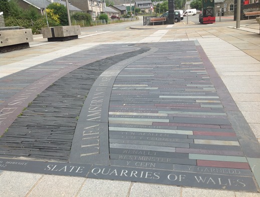
And with the little trains came a rebirth. If mining once sustained this part of Wales, then tourism does now. Blaenau now survives on its trains and also its old mines reopened as museums offering mine tours or extreme sports centres offering such niche delights as zip lines over slag heaps and underground trampolining in the merrily-named Bounce Below complex. And in line with this upbeat and trendy, new image, money has been spent refurbishing the town centre and both Rob and I liked their efforts. After a tasty lunch of traditional Welsh soup in a café staffed with Welsh speakers, we admired the new central plaza which has poetry etched in slate on the pavements and the names of each of the old mines engraved on one of their pieces of slate. I never realised the rock came in so many different shades. “I love this place,” declared Rob, who hadn't visited since he was a small child. “A small community made from and surrounded by rock; it’s powerful.”
And so it was and what's more it also gave us the first indication on our route that others were thinking like us. In the men's toilets next to the car park, there was an impressive Blaenau Ffestiniog word map blown up and plastered across the walls. And one of the largest words on there?
A470


No comments:
Post a Comment